
Completed with support from:

Alberta Lake Management Society
Address: P.O. Box 4283
Edmonton, AB T6E4T3
Phone: 780-702-ALMS
Water is integral to supporting and maintaining life on this planet as it moderates the climate, creates growth and shapes the living substance of all of Earth’s creatures. It is the tide of life itself, the sacred source.
David Suzuki(1997) The Sacred Balance
Alberta Lake Management Society’s Lakewatch Program
Lakewatch has several important objectives, one of which is to collect and interpret water quality data on Alberta Lakes. Equally important is educating lake users about their aquatic environment, encouraging public involvement in lake management, and facilitating cooperation and partnerships between government, industry, the scientific community and lake users. LakeWatch Reports are designed to summarize basic lake data in understandable terms for a lay audience and are not meant to be a complete synopsis of information about specific lakes. Additional information is available for many lakes that have been included in LakeWatch and readers requiring more information are encouraged to seek those sources.
ALMS would like to thank all who express interest in Alberta’s aquatic environments and particularly those who have participated in the Lakewatch program. These people prove that ecological apathy can be overcome and give us hope that our water resources will not be the limiting factor in the health of our environment.
Acknowledgements
The Lakewatch program is made possible through the dedication of its volunteers and Lakwatch Chairs, Al Sosiak and Ron Zurawell. We would like to thank Scott Lineker and Bob Lineker for their efforts in collecting data in 2009. We would also like to thank Noemie Jenni and Cristen Symes who were summer interns with ALMS in 2009. Project Technical Coordinator, Jill Anderson was instrumental in planning and organizing the field program. Technologists, Shelley Manchur, Mike Bilyk, Brian Jackson and John Willis were involved in the logistics planning and training aspects of the program. Doreen LeClair and Chris Rickard were responsible for data management. Théo Charette (ALMS President) and Jill Anderson (Program Manager) were responsible for program administration and planning. Francine Forrest, Jean-Francois Bouffard, and Théo Charette helped prepare the original reports, which were updated by Sarah Lord for 2009. Alberta Environment and the Beaver River Watershed Alliance (BRWA) were major sponsors of the Lakewatch program.
Muriel Lake: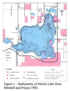
Muriel Lake (Figure 1) is located 13 km south of the town of
Bonnyville and 250 km northeast of Edmonton. Muriel Lake is a large (64.1 km²) but relatively shallow (mean and maximum deph 6.6 and 10.7 n, respectively) water body. The shoreline consists primarily of steep rocky slopes, but there are also several attractive sandy beaches.
The first non-native establishment in the area was a fur-trading post in 1781 by the North West Company near the present-day hamlet of Beaver Crossing, about 35 km northeast of Muriel Lake. The first settlers came to the Bonnyville area in 1907, and established an economy based on the timber industry. Two sawmills were located at Muriel Lake, one at the northeastern tip and the other on the large island/peninsula on the eastern shore. In the 1920’s a large fire forced the economic base to switch to agriculture.
Much of the watershed is occupied by Kehiwin Indian Reserve No. 123, which is located on 8200 ha of land southwest of the lake. There are several subdivisions around the lake shore, mostly on the south and east sides of the lake. The largest recreational facility on Muriel Lake, is Muriel Lake Park, which is operated by the Municipal District of Bonnyville. Muriel Lake is managed for domestic, sport and commercial fisheries. Northern pike, yellow perch, lake whitefish, and walleye are the sport fish found in the lake. Lake whitefish were stocked in 1937 and walleye are stocked periodically. The primary commercial species in lake whitefish, which constitutes about 95% of the total catch.
Muriel Lake is mesotrophic, with a moderate supply of nutrients and relatively low concentration of algae, and mixes periodically throughout the summer. Phytoplankton succession during the summer goes form golden-brown algae (Dinobryon spp.) in May, to diatoms (Fragilaria crontonensis) and dinoflagellates (Ceratium hirendinella) in June, and diatoms (Fragilaria crotonensis), blue-green algae, and green algae (Closterium spp.) in late summer. As a result of its clear water, aquatic plants can grow to a depth of 7 m in Muriel Lake and the littoral zone can cover almost 50% of the lake’s area. Emergent vegetation is largely restricted to areas sheltered from the wind. The northwest shore, although somewhat protected, has no emergent stands because of its rocky or sandy substrate. The dominant emergent species in 1978 were common great bulrush (Scirpus validus), and common cattail (Typha latifolia) and sedges (Carex spp.) closer to shore. The dominant submergent species was a large-sheath pondweed (Potamodeton vaginatus).
Results: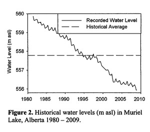
Water Level:
Water levels in Muriel Lake have declined steadily since 1981 (Figure 2), at which time the maximum lake elevation was recorded as 555.9 m asl. Water level has since declined by 3.92 m to its current elevation of 555.9 m asl, the lowest level on record. In many other lakes in Alberta the wet years of 1996 and 1997 resulted in peak water levels barely registered at Muriel Lake.
Water Temperature and Dissolved Oxygen:
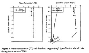
Water temperature and dissolved oxygen profiles in the water column can provide information on water quality and fish habitat. Please refer to the end of this report for descriptions of technical terms.
Thermal stratification in Muriel Lake was not observed during the summer of 2009 (Figure 3). Due to logistical constraints, a full depth profile for temperature and oxygen was taken only once, on 13 August. A partial profile ( to 1.0 m in depth) was taken on 16 July. Surface water temperature increased from 17.6°C on 16July to 19.9°C on 13 August. There was no temperature difference between surface and below waters, indicating the lake was isothermic. Dissolved oxygen (DO) concentrations in upper layers of surface waters of Muriel Lake were ≥ 8 mg/L on both sampling dates in 2009, well within the acceptable range for surface water quality (DO ≥ 5.0 mg/L) (Figure 3). DO concentrations declined at a depth of 3.0 m in August, but bottom waters were still well oxygenated.
Water Clarity and Secchi Depth:
Water clarity is influenced by suspended materials, both living and dead, as well as dissolved colored compounds in the water column. During the melting of snow and ice in the spring, lake water can become turbid (cloudy) from silt transported into the lake. Lake water usually clears in late spring but then becomes more turbid with increased algal growth as the summer progresses. The easiest and most widely used measure of lake water clarity is the Secchi disk depth.
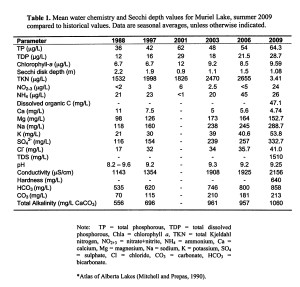
Water clarity on Muriel Lake was measured three times during the summer of 2009. Muriel Lake is of average turbidity compared to other lakes in Alberta, with average Secchi depth of 1.08 m (Table 1). On 16 July, light penetrated 1.25 m or ~35% of the current total lake depth, which allowed for algal growth in th top 2.5 m of the lake. By 13 August, Secchi depth had increased slightly to 1.5 m, but water clarity declined to a seasonal minimum of 0.5 m Secchi depth on 27 August. This pattern of water clarity dynamics is typical of highly productive Alberta lakes, when algal growth during July and August causes reduced water clarity. Water clarity typically recovers in September as lower temperatures limit growth, and dying algae fall out of the water column and settle on the lakebed where they are decomposed by anaerobic bacteria.
Water Chemistry:
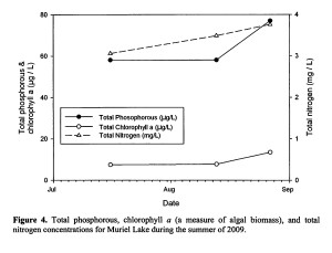
Based on lake water characteristics, Muriel Lake is considered eutrophic (see A Brief Introduction to Limnology at the end of the report). In 2009, Muriel Lake and high concentrations of total phosphorus (average TP = 64.3 μg/L), total nitrogen (average TN = 3434 μg/L) (Table 1). Total phosphorus increased over the summer, from 58 μg/L on 16 July and 13 August, to 77 μg/L on 27 August (Figure 4). Total nitrogen also increased over the summer, from 3.059 mg/L on 16 July to a seasonal maximum of 3.758 mg/L by 27 August. Cholophyll a (a measure of algal biomass) increased slightly from 7.49 μg/L on 13 August, and then rose sharply to 13.5 μg/L on 27 August.
During the summer 2009, Muriel Lake was well buffered from acidification with an average pH = 9.25, which is well above that of pure water (i.e., pH 7). Dominant ions include bicarbonate, sulfate, and carbonate (Table 1). Ion concentrations have increased significantly since the sampling began on Muriel Lake in 1988. This indicates a change in hydrology, potentially an increasing contribution of groundwater (which has high concentrations of ions) and a reduced contribution of surface runoff and throughflow. The reduction in water levels observed in Muriel Lake can also itself lead to a higher concentrations of ions.
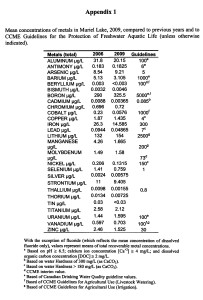
The average concentrations of various metals (as total recoverable concentrations) in Muriel Lake were measured twice in the summer of 2009. All concentrations were within CCME guidelines for the Protection of Freshwater Aquatic Life except for arsenic, which was nearly double the CCME guideline (Appendix 1).
References
Mitchell, P. and E. Prepas. 1990. Atlas of Alberta Lakes. University of Alberta Press.
Nürnberg, G.K. 1996. Trophic state of clear and colored, soft and hardwater lakes with special consideration of nutrients, anoxia, phytoplankton and fish. Lake and Reservoir Management 12(4): 432-447.
Strong, W.L. and K.R. Leggat. 1981. Ecoregions of Alberta. Alberta Energy and Natural. Resources. 64 pp.
Vollenweider, R.A., and J. Kerekes, Jr. 1982. Eutrophication of Waters. Monitoring, Assesment and Control. Organization for Economic Co-Operation and Development (OECD), Paris. 156 pp.
Welch, E.B. 1980. Ecological Effects of Waste Water. Cambridge University Press.
A Brief Introduction To Limnology
Indicators of Water Quality:
Water samples are collected in LakeWatch to determine the chemical characteristics that characterize general water quality. Though not all encompassing, the variables collected in LakeWatch are sensitive to human activities in watersheds that can cause degraded water quality. For example, nutrients such as phosphorus and nitrogen are important determinants of lake productivity. The concentrations of these nutrients in a lake are impacted (typically elevated) by land use changes such as increased crop production or livestock grazing. Elevated nutrient concentrations can cause increases in undesirable algae blooms resulting in low dissolved oxygen concentrations, degraded habitat for fish and noxious smells. A large increase in nutrients over time may also indicate sewage inputs which in turn may result in other health concerns associated with bacteria or the protozoan Cryptosporidium.
Temperature and Mixing: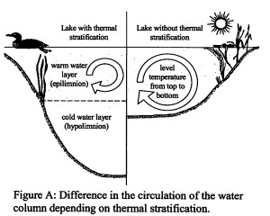
Water temperature in a lake dictates the behavior of many chemical parameters responsible for water quality.
Heat is transferred to a lake at its surface and slowly moves downward depending on water circulation in the lake. Lakes with a large surface area or a small volume tend to have a greater mixing due to wind. In deeper lakes, circulation is not strong enough to move warm water to depths typically greater than 4 or 5 m and as a result cooler denser water remains at the bottom of the lake. As the difference in temperature between warm surface and cold deeper water increases, two distinct layers are formed. Limnologists call these layers of water the epillimnion at the surface and the hypolimnion at the bottom. The layers are separated by a transition layer known as the metalimnion which contains the effective wall separating top and bottom waters called a thermocline. A thermoclibe typically occurs when water temperature changes by more than one degree within one meter depth. The hypolimnion and epilimnion do not mix, nor do elements such as oxygen supplied at the surface move downward into the hypolimnion. In the fall, surface waters begin to cool and eventually reach the same temperature as hypolimnetic water. At this point the water mixes from top to bottom in what is often called a turnover event. Surface water cools as ice forms and again a thermocline develops this time with 4°C water at the bottom and near 0°C water on the top.
In spring another turnover event occurs when surface water warm to 4°C. Lakes with this mixing pattern of two stratification periods and two turnover events are called dimictic lakes. In shallower lakes, the water column may mix from top to bottom most of the ice-free season with occasional stratification during periods of calm warm conditions. Lakes that mix frequently are termed polymictic lakes. In our cold climate, many shallow lakes are cold monomictic meaning a thermocline develops every winter, there is one turnover event in spring by the remainder of the ice free season the lake is polymictic.
Dissolved Oxygen:
Oxygen enters a lake at the surface and throughout the water column when produced by photosynthesizing plants, including algae, in the lake. Oxygen is consumed within the lake by respiration of living organisms and decomposition of organic material in the lake sediments. In lakes the stratify (see temperature above), oxygen that dissolves into the lake at the surface cannot mix downward into the hypolimnion. At the same time oxygen is depleted in the hypolimnion by decomposition. The result is that the hypolimnion of a lake can become anoxic, meaning it contains little or no dissolved oxygen. When a lake is frozen, the entire water column can become anoxic because the surface is sealed off from the atmosphere. Winter anoxic conditions can result in a fish-kill which is particularly common during harsh winters with extended ice-cover. Alberta Surface Water Quality Guidlines suggest dissolved oxygen concentrations (in the epilimnion) must not decline below 5 mg•L^-1 and should not average less than 6.5 mg•L^-1 over a seven-day period. However, the guidlines also require that dissolved oxygen concentrations remain above 9.5 mg•L^-1 in areas where early life stages of aquatic biota particularly fish, are present.
General Water Chemistry:
Water in lakes always contains substances that have been transported by rain and snow or have entered the lake in groundwater and inflow streams. These substances may be dissolved in the water or suspended as particles. Some of these substances are familiar minerals, such as sodium and chloride, which when combined form table salt, but when dissolved in water, separate into the two electrically charged components called ions. Most dissolved substances in water are in ionic forms and held in solution due to the polar nature of the water molecule. Hydrophobic (water-fearing) compounds such as oils contain little or no ionic character, are non-polar and for this reason, do not readily dissolve in water. Although hydrophobic compounds do not readily dissolve, they can still be transported to lakes by flowing water. Within individual lakes, ion concentrations vary from year to year depending on the amount and mineral content of the water entering the lake. This mineral content can be influenced by the amount of precipitation and other climate variables as well as human activities such as fertilizer and road salt application.
Phosphorus and Nitrogen:
Phosphorus and nitrogen are important nutrients limiting the growth of algae in Alberta lakes. While nitrogen usually limits agricultural plants, phosphorus is usually in shortest supply in lakes. Even a slight increase of phosphorus in a lake can, given the right conditions, promote algal blooms causing the water to turn green in the summer and impair recreational uses. When pollution originating from a livestock manure and human sewage enters lakes not only become a limiting nutrient which is thought to cause blooms of toxic algae belonging to the cyanobacteria. Not all cyanobacteria are toxic, however, the blooms can form decomposing mats that smell and impair dissolved oxygen concentrations in the lake.
Chlorophyll-a:
Chlorophyll a is a photosynthetic pigment that green plants, including algae, possess enabling them to convert the sun’s energy to living material. Chlorophyll a can be easily extracted from algae in the laboratory. Consequently, chlorophyll a is a good estimate of the amount of algae in the water. Some highly productive lakes are dominated by larger aquatic plants rather than suspended algae. In these lakes, chlorophyll a and nutrient values taken from water samples do not include productivity from large aquatic plants. The result, in lakes like Chestermere which are dominated by larger plants known as macrophytes, can be a lower trophic state than if macrophyte biomass was included. Unfortunately, the productivity and nutrient cycling contributions of macrophytes are difficult to sample accurately and are therefore not typically included in trophic state indices.
Secchi Disk Transparency:
Lakes that are clear are more attractive for recreation, whereas those that are turbid or murky are considered by lakes users to have poor water quality. A measure of the transparency or clarity of the water is performed with a Secchi disk with an alternating black and white pattern. To measure the clarity of the water, the Secchi disk is lowered down into the water column and the depth where the disk disappears is recorded. The Secchi depth in lakes with a lot of algal growth will be small while the Secchi depths are not caused by algal growth can be very deep. Howver, low Secchi depths are not caused by algal growth alone. High concentrations of suspended sediments, particularly fine clays or glacial till, are common in plains or mountain reservoirs of Alberta. Mountain reservoirs may have exceedingly low Secchi depths despite low algal growth and nutrient concentrations.
The euphotic zone or the maximum depth that light can penetrate into the water column for actively growing plants is calculated as twice the Secchi depth. Murky waters, with shallow Secchi depths, can prevent aquatic plants from growing on the lake bottom. Conversely, aquatic plants can ensure lakes have clear water by reducing shoreline erosion and stabilizing lake bottom sediments. In Alberta, many lakes are shallow and bottom sediments contain high concentrations of nutrients. Without aquatic plants, water quality may decline in these lakes due to murky, sediment laden water and excessive algal blooms. Maintaining aquatic plants in certain areas of a lake is often essential for ensuring good water clarity and a healthy lake as many organisms, like aquatic invertebrates and insects, depend on aquatic plants for food and shelter.
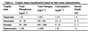
Trophic State: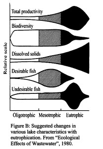
Trophic state is classification of lakes into four categories of fertility and is a useful index for rating and comparing lakes. From low to high nutrient and algal biomass (as chlorophyll) concentrations, the trophic states are olligotrophic, mesotrophic, eutrophic and hypereutrophic (Table 2).
A majority of lakes in Alberta contain naturally high levels of chlorophyll a (8 to 25 μg/L) due to our deep fertile soils. These lakes are usually considered fertile and are termed eutrophic. The nutrient and algal biomass concentrations that define these categories are shown in the following table, a figure of Alberta lakes compared by tropic state can be found in the ALMS website.